


In the mobile Internet era, people are increasingly using mobile apps for a variety of different purposes, such as buying products online, hailing taxis, and much more. When using such an app, a user usually needs to manually enter their address for package delivery or search for an appropriate pick-up and drop-off location when they hail a taxi, which can be inconvenient.
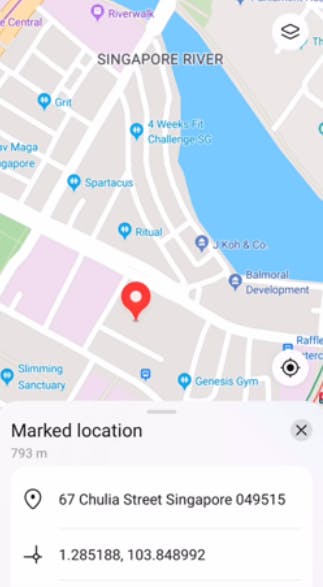
To improve user experience, many apps nowadays allow users to select a point on the map and then use the selected point as the location, for example, for package delivery or getting on or off a taxi. Each location has a longitude-latitude coordinate that pinpoints its position precisely on the map. However, longitude-latitude coordinates are simply a string of numbers and provide little information to the average user. It would therefore be useful if there was a tool which an app can use to convert longitude-latitude coordinates into human-readable addresses.
Fortunately, the reverse geocoding function in HMS Core Location Kit can obtain the nearest address to a selected point on the map based on the longitude and latitude of the point. Reverse geocoding is the process of converting a location as described by geographic coordinates (longitude and latitude) to a human-readable address or place name, which is much more useful information for users. It permits the identification of nearby street addresses, places, and subdivisions such as neighborhoods, counties, states, and countries.
Generally, the reverse geocoding function can be used to obtain the nearest address to the current location of a device, show the address or place name when a user taps on the map, find the address of a geographic location, and more. For example, with reverse geocoding, an e-commerce app can show users the detailed address of a selected point on the map in the app; a ride-hailing or takeout delivery app can show the detailed address of a point that a user selects by dragging the map in the app or tapping the point on the map in the app, so that the user can select the address as the pick-up address or takeout delivery address; and an express delivery app can utilize reverse geocoding to show the locations of delivery vehicles based on the passed longitude-latitude coordinates, and intuitively display delivery points and delivery routes to users.
Bolstered by a powerful address parsing capability, the reverse geocoding function in this kit can display addresses of locations in accordance with local address formats with an accuracy as high as 90%. In addition, it supports 79 languages and boasts a parsing latency as low as 200 milliseconds.
Demo
The file below is a demo of the reverse geocoding function in this kit.
Preparations
Before getting started with the development, you will need to make the following preparations:
Register as a Huawei developer and complete identity verification on the HUAWEI Developers website. You can click here to find out the detailed registration and identity verification procedure.
Create a project and then create an app in the project in AppGallery Connect. Before doing so, you must have a Huawei developer account and complete identity verification.
Generate a signing certificate fingerprint and configure it in AppGallery Connect. The signing certificate fingerprint is used to verify the authenticity of an app. Before releasing an app, you must generate a signing certificate fingerprint locally based on the signing certificate and configure it in AppGallery Connect.
Integrate the Location SDK into your app. If you are using Android Studio, you can integrate the SDK via the Maven repository.
Here, I won't be describing how to generate and configure a signing certificate fingerprint and integrate the SDK. You can click here to learn about the detailed procedure.
Development Procedure
After making relevant preparations, you can perform the steps below to use the reverse geocoding service in your app. Before using the service, ensure that you have installed HMS Core (APK) on your device.
i. Create a geocoding service client.
In order to call geocoding APIs, you first need to create a GeocoderService instance in the onClick() method of GeocoderActivity in your project. The sample code is as follows:
Locale locale = new Locale("zh", "CN");
GeocoderService geocoderService = LocationServices.getGeocoderService(GeocoderActivity.this, locale);
ii. Obtain the reverse geocoding information.
To empower your app to obtain the reverse geocoding information, you need to call the getFromLocation() method of the GeocoderService object in your app. This method will return a List object containing the location information based on the set GetFromLocationRequest object.
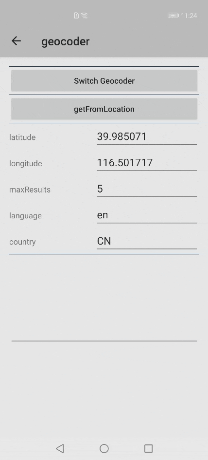
a. Set reverse geocoding request parameters.
There are three request parameters in the GetFromLocationRequest object, which indicate the latitude, longitude, and maximum number of returned results respectively. The sample code is as follows:
// Parameter 1: latitude
// Parameter 2: longitude
// Parameter 3: maximum number of returned results
// Pass valid longitude-latitude coordinates. If the coordinates are invalid, no geographical information will be returned. Outside China, pass longitude-latitude coordinates located outside China and ensure that the coordinates are correct.
GetFromLocationRequest getFromLocationRequest = new GetFromLocationRequest(39.985071, 116.501717, 5);
b. Call the getFromLocation() method to obtain reverse geocoding information.
The obtained reverse geocoding information will be returned in a List object. You can add listeners using the addOnSuccessListener() and addOnFailureListener() methods, and obtain the task execution result using the onSuccess() and onFailure() methods.
The sample code is as follows:
private void getReverseGeocoding() {
     // Initialize the GeocoderService object.
    if (geocoderService == null) {
        geocoderService = new GeocoderService(this, new Locale("zh", "CN"));
    }
    geocoderService.getFromLocation(getFromLocationRequest)
            .addOnSuccessListener(new OnSuccessListener<List<HWLocation>>() {
                @Override
                public void onSuccess(List<HWLocation> hwLocation) {
                    // TODO: Define callback for API call success.
                    if (null != hwLocation && hwLocation.size() > 0) {
                        Log.d(TAG, "hwLocation data set quantity: " + hwLocation.size());
                        Log.d(TAG, "CountryName: " + hwLocation.get(0).getCountryName());
                        Log.d(TAG, "City: " + hwLocation.get(0).getCity());
                        Log.d(TAG, "Street: " + hwLocation.get(0).getStreet());
                    }
                }
            })
            .addOnFailureListener(new OnFailureListener() {
                @Override
                public void onFailure(Exception e) {
                    // TODO: Define callback for API call failure.
                }
            });
}
Congratulations, your app is now able to use the reverse geocoding function to obtain the address of a location based on its longitude and latitude.
Conclusion
The quick development and popularization of the mobile Internet has caused many changes to our daily lives. One such change is that more and more people are using mobile apps on a daily basis, for example, to buy daily necessities or hail a taxi. These tasks traditionally require users to manually enter the delivery address or pick-up and drop-off location addresses. Manually entering such addresses is inconvenient and prone to mistakes.
To solve this issue, many apps allow users to select a point on the in-app map as the delivery address or the address for getting on or off a taxi. However, the point on the map is usually expressed as a set of longitude-latitude coordinates, which most users will find hard to understand.
As described in this post, my app resolves this issue using the reverse geocoding function, which is proven a very effective way for obtaining human-readable addresses based on longitude-latitude coordinates. If you are looking for a solution to such issues, have a try to find out if this is what your app needs.